


The Old Telegraph Track – the fair dinkum Cape
Apologies for this quite long winded blog, but there’s heaps of grouse stuff to write about, well at least for me! The track has been the highlight of the trip so far. This is some of the best country in OZ and it’s been some of the best 4wding we’ve ever done. So those that aren’t into 4wding maybe just check out the pics.
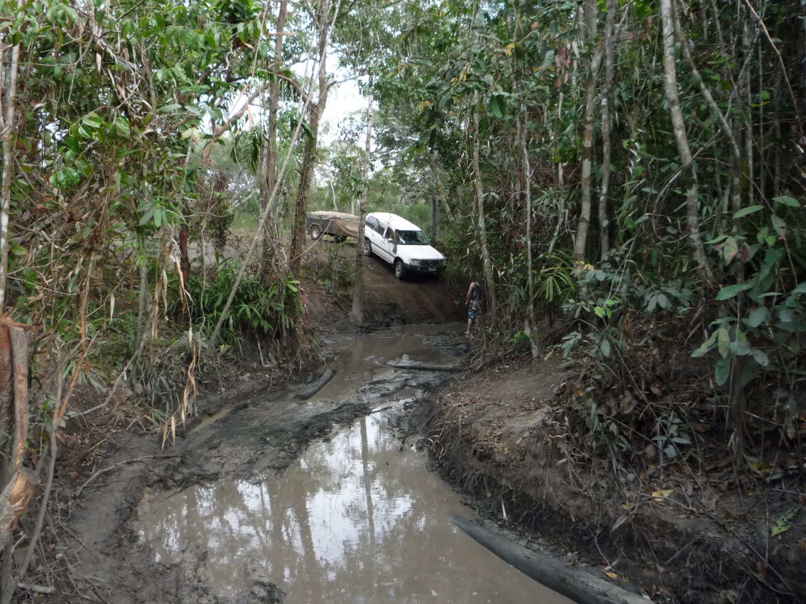
Here’s some captions to the images, from top to bottom:
1. Crossing Nolan Brook (Bridge Creek) on the Old Telegraph Track (OTT)
2. North Kennedy River in Lakefield National Park
3. Termite Mound in western part of Lakefield National Park
4. Old Telegraph pole just north of Bramwell Junction
5. Dropping down into Gunshot Creek, OTT
6. Posing under the trophy tree at Gunshot Creek
7. Eliot Falls
8. Mucking around at The Saucepan falls on Eliot Creek
9. Saucepan Falls pool
10. Twin Falls, Canal Creek just before they drop into Eliot Creek
11. The family shot at the Jardine River crossing
12. Fruit Bat Falls, upper Eliot Creek
It was a good drive north from Cooktown through some really lush countryside - the locals at Cooktown said July was unusually cool with prevailing south-easterlies and many days of misty rain, hence why everything looked so green in the “dry season”. We took the Battle Camp Rd to Old Laura Station which is now part of Lakefield NP. It was from here the road deteriorated and bad corrugations became the norm. We setup at Hann Crossing for two nights, a great little campsite on the North Kennedy River. They say Lakefield they say is similar to Arnhem Land. Nice place, but shame there’s no swimming again due to Mr Croc, though we didn’t see any. If you’re big into fishing this is the place to come. The kids fished a bit with no luck. We were entertained one day by a python that made its way slowly from one tree to another. We saw a heap of frogs (and Cane Toads), and as the saying goes – where there’s frogs you’ll find snakes, made one careful especially at night wandering around camp!
We left Lakefield and headed west, with slight diversions to Low and Sweetwater lakes in the park - both are shallow lakes mostly covered in lilies. They were also teeming with water birds, some of which were Magpie Geese and “Jesus” birds. Sadly on the final stint to Musgrave Roadhouse we ran over a snake, though from our earlier experiences he’s got many more mates out there. At Musgrave, which is one of the old telegraph stations we scoffed some icecreams and caught up with a couple we’d met at Cooktown who were travelling with a 10 month old boy! Another hour and a bit north and we were at Coen, not much of a town to look out but the biggest on the Cape. We had lunch here and grabbed some more fuel and supplies. There was a camp spot 3km north of Coen we’d hope to stop at but it was pretty well full up so we kept going through to Archer River Roadhouse, and as the name suggest sits on the banks of the beautiful Archer River. Really surprised with how good the road had been to here, it was in really good condition except for a few sections of corrugations. We had a little light rain during the day which was good as it reduced the dust, but wasn’t enough to turn the road to mud. We had more rain during the night and packed up in the morning with wet canvas.
On the road again and it was only 50 odd km to the Weipa turnoff where we thought the road would get worse, but though it narrowed slightly we were pleasantly surprised how good it was right through to Bramwell Junction Roadhouse, passing another old telegraph station (Moreton) along the way. Bramwell is where the Old Telegraph Track branches off. We grabbed some drinks and topped up with fuel, with the girl there telling me that at the first creek crossing (4km away) they’d been winching vehicles up there during the last week. I thought since we’d come all this way we’d at least head down and see what condition it was in. When we got there (Palm Ck) I first thought there must be another option as there were tracks heading right along the bank – soon realised though there was only one option, straight ahead and down a 3ft drop into mud and logs! A Troopie pulled up and said he’d hang around and pull us out if we wanted to give it a go – what the heck, we aired down and got the recovery gear ready. My passengers abandoned ship and left me to it, as well as making sure the moment was captured on camera, no matter how it turned out! In the end it was pretty straight forward, after slipping down the bank and coming to a crunch at the bottom it was a slow cruise across the creek and a bit of wheel slipping to get up the steep wet muddy bank on the other side. Only damage was one of the trailer stays being bent up – one major water crossing down, only 13 to go! Ducie Creek was the next one, and are new mate in the Troopie (as different to our old mate Mr Truckin) hung around to help out again if needed – apart from some more crunching no issues at all. We had one more crossing at North Alice Ck before setting up camp on the south bank of the Dulhunty River. This southern bit of the track gets a lot less traffic then the northern section and is some of the best 4wding you can do. It’s basically just two wheel tracks heading along the old telegraph line, with numerous diversions wherever the old track had been washed out or a tree had fallen across the track. Many of the original telegraph poles are still standing, though all the isolators have been souvenired. Apart from our Troopie mate we didn’t see anyone else at all along the track except at the camping spot – thankfully most people do it from south to north, reducing the real chance of a head-on.
Up early the next day as we wanted to make sure we got to the popular Eliot/Twin Falls campsite early enough to get a spot. After Dulhunty Rv, the next crossing of the day was Bertie Ck which was a great rocky crossing where we had to head upstream 50m or so before exiting. It was another 4km before we had to make the decision whether to take the bypass around the famous Gunshot Creek crossing or not. I thought what the heck let’s head the 12km up the OT track to see what condition the crossing was in and whether there was a “chicken” track. We got there to see a guy in a 80 series Landcruiser trying to get up the “chicken” track, all he proceeded to do was chew the hell out of the track and didn’t get anywhere. He finally decided to do what he should have done first up and that was winch himself up! He actually broke the casing on his winch – karma. I didn’t fancy driving the 12km back at 20kmh so thought we’d give the crossing a go as he was heaps of people around to help out, or more to the truth waiting for people to come a croppa! So out the shovel came and I did a bit of work repairing some of the damage the d-head in the 80 series had done. Then once again all passengers abandoned ship – it was a very slow entry and then a slip into the mud and crap at the bottom of the creek. Once in the creek bed itself we were virtually home and hosed – it was nice to have one of the guys originally spectating guiding me through. (Pete – reckon the Falcon might have struggled to get through this one, even with the bench seat!) Stopped for photos under the “trophy” tree and then cruised up the opposite bank. No damage at all this time! (If interested google “Gunshot Creek” or do a search on YouTube and see some silly things boys have done in their toys up and down the harder chutes at Gunshot). After that we had two more crossings at Cockatoo and Sailor Creeks before getting to the Eliot Falls Campground around lunch. Once camp was setup we bolted down to the Saucepan Falls to cool off. It was bloody good feeling having a beer later knowing we’d had such a great day 4wding.
Sleep in the next day and lazing around camp, I even managed a shave which Louise was pretty happy about. We swum at all of the great swimming spots here – Eliot and Twin Falls and The Saucepan Falls, all of which are within 500m of each other. The water is so clear and a great temp. In the arvo we got out the snorkel gear and snorkelled up and under Eliot Falls, seeing some Catfish and other larger fish. There are some deep pools here, filled with logs and rocks and I couldn’t help but think how a freshie could easily sit on a ledge down there and we’d hardly notice! The wildlife of note here is fruit bats (or flying foxes) and there’s thousands upon thousands of the upside down critters. They stink a lot and you’ve got to be careful (or lucky) when walking down for swim that you don’t get shat on. Late arvo and they take to the sky, a pretty amazing site. We’re running out of fresh food, in fact food in general so Louise has been very creative in the culinary stakes – hanging out for some fresh fruit.
What a day! We left the trailer at Eliot Falls Campground and headed north to do the final section of the OT track to the Jardine River, which is the biggest river on the Cape. Things got interesting early, at Canal Ck, the first water crossing only a km down the track I got the rear diff caught up on a rock ledge heading into the creek, in the end the solution was a little more right foot and we were on our way. This part of the track is amazing with probably the most challenging water crossings, most having steep entry and exits with eroded banks. We got through Sam, Mistake and Cannibal Creek crossing without any problems. Next was Cypress Ck which was a bridge of sorts – a number of poles or logs just laid down over a small gully - Louise’s precise directions got us over that safely. After this we came to a serious crossing which was only marked on the map as a ford – it was quite long and reasonably deep in the middle. It was at this point two 80 series Cruisers caught up to us as we were working out which was the best option across. I followed the first one over (in case we needed a snatch) with no problems. We left the other one (which was petrol) to fit his water blind and headed on. We got to Nolan’s Brook (also known as Bridge Creek) to find the log bridge that used to be there is no more. As this was the deepest crossing on the track we decided to wait for our new friends, who were from Seville – it is a small world. Once they arrived we walked the crossing and decided one entry was better than the other. Not sure why but we were the first vehicle to give it a go – 2nd Low range and with the front locker engaged I headed through (crew again decided watching was better!). The bottom dropped off in the middle with really loose coarse sand and for a moment as I lost traction climbing out of the deep water I thought I was in trouble, but the trusty Toyota pulled itself out. Next was the guy with the diesel, and as he was climbing out he lost traction and was stuck – we chucked a snatch strap on and I pulled him out. Only problem was he’d already been in the water for a few minutes and when he opened the doors on firm ground, water came pouring out from everywhere – sadly one of the casualties was their laptop. He was a bit unlucky as I’d probably chewed up the bottom a bit, though he was running higher tyre pressures and didn’t have any lockers. We found out later that three other vehicles had got across after us but they all had lockers front and rear). Mr Diesel then pulled Mr Petrol though after we joined two snatch straps. Once we were all across we had a swim and somehow a fruit cake appeared (and a thankyou beer) from one of the 80 series which tasted great. Off again and it was a cruisy trip up to the Jardine River, and it wasn’t what I’d expected - rather than being deep, muddy and dark (and teeming with crocs) as I had envisaged, at this point it was quite shallow, wide and with white sand beaches similar to the Murray River near Yarrawonga and Cobram. We checked out the old vehicle crossing (they now have a ferry downstream) and it’s over 140m across, and probably averages 2 to 3 feet deep. People still do it and even walk it first to check for holes, soft sand etc keeping a watchful eye out for crocs. On the way back to camp we took the main road and stopped off at Fruit Bat Falls for a swim, another great set of falls on the upper bit of Eliot Creek with pristine clear waters. Back at camp we enjoyed a nice cold beer.


2 comments:
Well, aren't you having the best time! Lucky I have the 1977 edition of Readers Digest map of Australia. The only roads shown on that map are the OTT and the outstations. There is no Lakefield National Park in 1977 but all the buildings are shown.
Thanks for the call and glad all is well. Chris certainly enjoyed the ride and made sure it was all captured for posterity. Great photos but not as spectacular as Lachlan's wipe-out at Clifton Beach.
Bit hard deciphering the 4wd talk. Googled 'troopie' and found the LC70 or was it and old 88' Trooper LS 2.6L?
Loved the shot of the drop into Eliot Creek. Not such a good landing for Chantal being sandwiched between the boys. Seems as though you are a little ahead of time as I expected you on Thursday Island next Saturday for voting day.
Thanks for the long blog. Have printed out and sent to Nanna.
Love to all,
Mum & Dad
Thank you for a well documented and interesting account of the Telegraph Track.
Post a Comment