After a quick shop we left Weipa and did 250 odd km before stopping for lunch just north of Coen on the Coen River. After lunch we didn’t get much further and setup camp at Musgrave Roadhouse – the road had been pretty good overall but I’d had enough of it by mid arvo.
Next day and we headed south from Musgrave, new territory for us as on the way up we’d met the main road at Musgrave coming in from the east. We stopped at Laura at the cultural centre which had great displays covering both aboriginal and early white settlement in the area. It was only a hop, skip and a jump down the road to the Split Rock Aboriginal Art site, one of the few that are accessible to the public. There was a great little creek and waterhole hidden across the road where we had lunch – apparently it was croc free but the kids weren’t game to try it out! 50km down the road got us to Lakeland and back on the black stuff again. We’d done just over 2200km on dirt roads (did I mention Louise is over the dust !@#$%^&*), and just ticked over 10,000km for the trip so far. Filled up with fuel at Lakeland (back to $1.41 a litre, compared to $1.95 we paid way up north) and enjoyed a cruisy hour and a bit to Mount Carbine where we camped for the night.
First stop next day was Mareeba, a place we’d stopped at before on our way to Cairns from the Gulf, but this time instead of rain sunshine greeted us. We checked out their great info centre which included a really cool interactive museum with stuff the kids were interested in. Chantal also got to tick off another of her big things, getting a shot in front of the Brahmin Bull. Next stop was Atherton with a quick break at the info centre trying to find a cloth badge and hat pin of Cairns (more on that later!). From there on the way down to the coast we stopped at Yungaburra for lunch and a walk along their creek to try and spot Platypus – no luck there but we did see a number of turtles and a couple of big water dragons. Leaving there we stopped in at the Curtain Fig Tree, a humongous fig tree just out of Yungaburra and then Lake Eacham which is an old volcanic crater which had a nice walk to two giant Kauri Pines. The road from there (on the Atherton Tablelands) down to Gordonvale on the coast was interesting to say the least, with over 40km of windy descending with some serious drop-offs. Now up to this point the kids hadn’t got badges of Cairns (apparently I’d said we’d be going back through there!) so at Gordonvale we a 50km detour up to Cairns and back to purchase said badges, during peak hour with trailer in tow – things we do for our kids! Anyway that night we stayed at Bramston Beach with a beachfront spot and saw the full moon rise over the water in a ball of red. The locals had a full moon bonfire with music on the beach which was nice to fall asleep to.
In the morning we headed back up the hwy and turned off at Babinda and saw the Babinda Boulders. Down the highway we went to Josephine Falls where the kids swam and slid down the big rock face into the pool below – this gorge I reckon was better than Mossman Gorge. We wanted to stay at Etty Bay which is just south of Innisfail and on the way in there we were lucky enough to have a cassowary walk in front of us and hang around for a short period of time on the side of the road – sadly it was too dark for a good photo. Etty Bay was full so we went to Paronella Park which is in Mena Creek (inland on the old Bruce Hwy). Paronella Park is 13 odd acres of amazing gardens and buildings built by a crazy Spaniard in the 1930s, all out of concrete, reo rod and cane rail tracks. You’d have thought he was Italian when you see the amount of concrete he used, and all hand mixed. Sadly most of the structures now have concrete rot and the current owners are having a struggle to preserve them and that’s not taking into account the cyclones and floods that seem to occur every five years or so. That evening we did the night tour in the rail and dried out later at the pub for a counter meal. If you want to see some good pics of the place check out: http://www.paronellapark.com.au/
Next morning we were up early and checked out the park by ourselves in daylight, feeding a heap of fish and turtles they have. After brekky we did the day tour which gave us a better insight into the why and how the place came about. The kids highlight was seeing the hundreds of micro-bats in the “tunnel of love”. We headed south along the old Bruce Hwy and went to Bingil Bay hoping to stay there but they were full so we ended up at Mission Beach and got a nice spot close to the beach with walking distance to the cafes and shops. Not beach weather though as it was the first night we had jeans and long sleeve tops on for over 5 weeks!
Today has been spent checking out the area and doing a few rainforest walks trying to spot another cassowary. No luck on that account, though on one of the walks there was a heap of fresh droppings, but no big birds. The kids got the boogie boards out this arvo on the huge 2ft swell, the sun wasn’t out but at least it’s a little warmer than yesterday. Good beach frisbie weather though. Tomorrow is Mission Beach’s big monthly market which should be good. MB has surprised us a bit, we thought it would be a lot more developed, but that’s not the case. There are still vacant blocks metres from the beach at good prices, and that is surprising as this must be one of the most amazing beaches in all of OZ.
From Punsand we headed south, again stopping at Bamaga to stock up on supplies. One thing we
overlooked was grog, thinking we could get some further south – sadly not to be! The road was pretty good, most of it we hadn’t travelled on when coming up as we’d gone up the Old Telegraph Track. We had a little detour to Bramwell Station hoping to get some lunch, but we were out of luck as they only did dinner. So we headed to Bramwell Junction and had a great burger there, donating our recently purchased lettuce as they had run out and the supply truck wasn’t due to the next day. From there we had a slow drive to Moreton Telegraph Station which is on the Wenlock River and had a relaxing arvo there. Apparently this is a good spot to see the Palm Cockatoo, we only knew this when a tour group of birdo’s were running around very excitedly – we got to hear him but not see him in the flesh.
In Moreton we heard that there was a rodeo in Weipa on the weekend so we headed in that direction. We made a short day of it and stopped at Merluna Station, about 120km SE from Weipa. They just run cattle here, and with over 400,000 acres they have a heap of room to run them! Cattle prices in general aren’t good at the moment so Merluna and a number of other stations haven’t sold any cattle for a few years now. It was an interesting stay, all their kids are off the station at the moment, one at boarding school at Townsville, one of the girls droving in the Gulf, while the oldest of the girls was following the boyfriend on the rodeo circuit in Canada. We had dinner with the family and station hands, a good ole dish of steak and vegies. It was at Merluna that I noticed an oil leak around the passenger side CV boot – Cameron (the station owner) had a closer look at it in the morning but wasn’t sure what it was – their machinery is more tractor like! The kids enjoyed checking the station out including a couple pigs soon to end up on the dinner table.
It was only a short hike into Weipa the next morning. We were hoping to hang around to see Merluna’s mail plane arrive but I was pretty keen to get into Weipa to get the oil leak checked out as the weekend was fast approaching. At the campground we got another great spot right on the beach with heaps of shade. The kids were doubly rapt as it has a great pool, which is handy when the beach is again off limits due to crocs. After setting up camp I headed off asap to get the cruiser checked out. As expected they were flat out and with a quick inspection they weren’t sure where the leak was coming from – they said to come back early in the morning and they’d put it on the hoist.
So it was back there next day, and once we had the bash plates off, my worst fear of a stuffed diff seal was happily put to rest. It ended up being relatively minor – the front diff breather had been ripped off close to the diff, not sure how as it’s pretty well protected! It must have happened a few river crossing back as the diff was full of water! We did a temporarily fix as part of the breather was missing which should see us get back to Melb no probs, and filled the diff up with some good oil. The oil in the rear diff and transmission was fine so that was reassuring after all the water crossings.
Weipa is a Rio Tinto (ex Camalco) Mining town with a population around 3000. They mine for Bauxite which is the raw material for aluminium. Most of it goes to Gladstone by ship for processing.
We got in some shopping at the only shopping centre. Interestingly I was not allowed to buy a cask of wine at lunchtime (local liquor laws), I had to come back after 5pm when there was a limit of two casks per person. When I rocked back there at 6.30 the whole fridge was virtually empty, I got one of four casks left. The guy there said that if you aren’t there at 5pm each day there’s a good chance you’ll miss out! Mid arvo we headed off to the rodeo, one of the two major attractions of the year, the other being the fishing comp. This was a bull riding only event, but was entertaining enough to keep us there for over six hours. There was a huge community turnout with both white and indigenous locals. The bull riders and the clowns are crazy guys, not sure who is crazier, with one of the clowns taking a serious hit with one bull lifting him up on top of the railings which are about 2m high. Dinner for the evening was a few cans of XXXX and a meat lovers pizza, can’t get more country than that.
Today was another cruisy day with not doing much except taking in a mine tour in the morning. It was sort of nice to be driven around rather than drive yourself. Two hours saw us see the ins and outs of the town as well as have a real close up look at the mine workings. Big Tonkas up here and not all blokes toys with about 25% of the drivers being female (they reckon they treat the trucks better, and therefore get more mileage out of them – yeah right !). Nothing cheap with these machines either - one tyre alone for one of the loaders up here costs $40,000, Louise shouldn’t ever complain about the cost of the Coopers again! Arvo we took in a walk down the beach and later watched the sunset over the gulf, the last for us before we head south (& east).
It’s been warmish up here hitting 34 today, but also it’s been very windy. Heading south tomorrow, not sure where we’ll get to, but it will probably be somewhere around Musgrave Telegraph Station.
Yesterday we headed over to Thursday Island or TI as the locals call it. I think it was somewhere around 45km from Punsand Bay where we’re camped. We took off early and it was a beautiful trip over, passing between some of the bigger islands to get there, one of which was Horn Island which has a heap of war history. Just on an hour saw us rock up at one of the jetties at TI.
(I’ve chucked in some maps this time for those interested)
We were then off on a two hour tour, which is about right as the width of TI is only around 3km. First up we had a look around the old fort which was on one of the two high points on the island – it was built in the early 1900s in preparation for the invading Russians, the locals say they’re still waiting! Next was the cemetery which had over 700 graves of Japanese divers who had died during the pearling days. Last attraction was the Crayfish factory where they explained how they catch them up here (by hand, no pots) and how they send them to Cairns and then onto Hong Kong by plane, arriving there alive.
Once the tour was over the first thing we got out of the way was our voting duties, apparently the northern most polling booth in OZ. We checked out the shops in town, the kids trying to find the best cloth and hat badges. I was quite surprised how developed TI is, they seem to have everything, including a quite substantial hospital and a number of schools. We dropped past the northern most pub in OZ for a shot and looked through the Cultural Centre which was very good, also having lunch at the great little cafe there – the kids thought the hammock in the garden was great.
The cruise back was interesting to say the least. The wind had picked up quite strongly and the skipper had to constantly slow down, speed up and turn to avoid smashing into some of the bigger swells. It was fun though, with a few people getting sick. And best of all, one of them was not Lachlan, he seems to have finally found his sea legs!
We decided to stay at Punsand another day, and we’ve had a very lazy day indeed, going for a walk in the morning. We’re heading south tomorrow, not yet syre where we’ll be tomorrow night, maybe another day on the coast somewhere.
The weather is still warm, high 20s at a guess. Interestingly we’ve had light rain off and on most days over the last three weeks.
Just a shorty today - we did a day trip up to the Cape from the Punsand Bay Campground/Resort. Yesterday we drove from Eliot Falls Campground through to Punsand with only one minor drama, ripping the front number plate off on the last water crossing out! Later we passed thru Bamaga and Seisia to do some shopping.
Up was up early today hoping to beat the crowds to the tip. We headed off about 8am and it was only a 45 min drive along some crappy roads to get up there, meeting a group we’d met along the OTT who had got up there to watch the sun come up – very keen campers they were! It’s only a 15min or so walk from the car-park out over the headland to the Cape proper – we added a few rocks to the cairns along the way and got there to find out we had the place to ourselves. The tip doesn’t get much of a write up in the beauty stakes, but it really is quite stunning with a beautiful white beach to the west and a couple of specky islands just off shore, York and Eborac (which has a lighthouse on it). We made sure we got in the customary snaps before anyone arrived – we didn’t really need to worry in the end as we ended up having the place to ourselves for approx 45mins. And the kids could finally say – Yep, we are finally there! We were also treated to three dolphins making their way past and turtles constantly bobbing up for air. The oldie tour groups soon arrived and the women in one group insisted on partially stripping down and draping an Aussie flag around them, the aim being to give the impression that’s all they had on! As it was low tide we walked back along the beach to the carpark.
On the way back to camp we made a detour to Somerset, the original settlement on the tip. Not much there now but there was a nice little beach and some historic graves. We kids spent the arvo in the pool, fishing off the beach and playing frisbie. Our camp site has an amazing view, you virtually take one big step from the end of the annex and you’re on the beach.
Tomorrow we’re off to Thursday Island – more on that soon.
Apologies for this quite long winded blog, but there’s heaps of grouse stuff to write about, well at least for me! The track has been the highlight of the trip so far. This is some of the best country in OZ and it’s been some of the best 4wding we’ve ever done. So those that aren’t into 4wding maybe just check out the pics.
Here’s some captions to the images, from top to bottom:
1. Crossing Nolan Brook (Bridge Creek) on the Old Telegraph Track (OTT)
2. North Kennedy River in Lakefield National Park
3. Termite Mound in western part of Lakefield National Park
4. Old Telegraph pole just north of Bramwell Junction
5. Dropping down into Gunshot Creek, OTT
6. Posing under the trophy tree at Gunshot Creek
7. Eliot Falls
8. Mucking around at The Saucepan falls on Eliot Creek
9. Saucepan Falls pool
10. Twin Falls, Canal Creek just before they drop into Eliot Creek
11. The family shot at the Jardine River crossing
12. Fruit Bat Falls, upper Eliot Creek
It was a good drive north from Cooktown through some really lush countryside - the locals at Cooktown said July was unusually cool with prevailing south-easterlies and many days of misty rain, hence why everything looked so green in the “dry season”. We took the Battle Camp Rd to Old Laura Station which is now part of Lakefield NP. It was from here the road deteriorated and bad corrugations became the norm. We setup at Hann Crossing for two nights, a great little campsite on the North Kennedy River. They say Lakefield they say is similar to Arnhem Land. Nice place, but shame there’s no swimming again due to Mr Croc, though we didn’t see any. If you’re big into fishing this is the place to come. The kids fished a bit with no luck. We were entertained one day by a python that made its way slowly from one tree to another. We saw a heap of frogs (and Cane Toads), and as the saying goes – where there’s frogs you’ll find snakes, made one careful especially at night wandering around camp!
We left Lakefield and headed west, with slight diversions to Low and Sweetwater lakes in the park - both are shallow lakes mostly covered in lilies. They were also teeming with water birds, some of which were Magpie Geese and “Jesus” birds. Sadly on the final stint to Musgrave Roadhouse we ran over a snake, though from our earlier experiences he’s got many more mates out there. At Musgrave, which is one of the old telegraph stations we scoffed some icecreams and caught up with a couple we’d met at Cooktown who were travelling with a 10 month old boy! Another hour and a bit north and we were at Coen, not much of a town to look out but the biggest on the Cape. We had lunch here and grabbed some more fuel and supplies. There was a camp spot 3km north of Coen we’d hope to stop at but it was pretty well full up so we kept going through to Archer River Roadhouse, and as the name suggest sits on the banks of the beautiful Archer River. Really surprised with how good the road had been to here, it was in really good condition except for a few sections of corrugations. We had a little light rain during the day which was good as it reduced the dust, but wasn’t enough to turn the road to mud. We had more rain during the night and packed up in the morning with wet canvas.
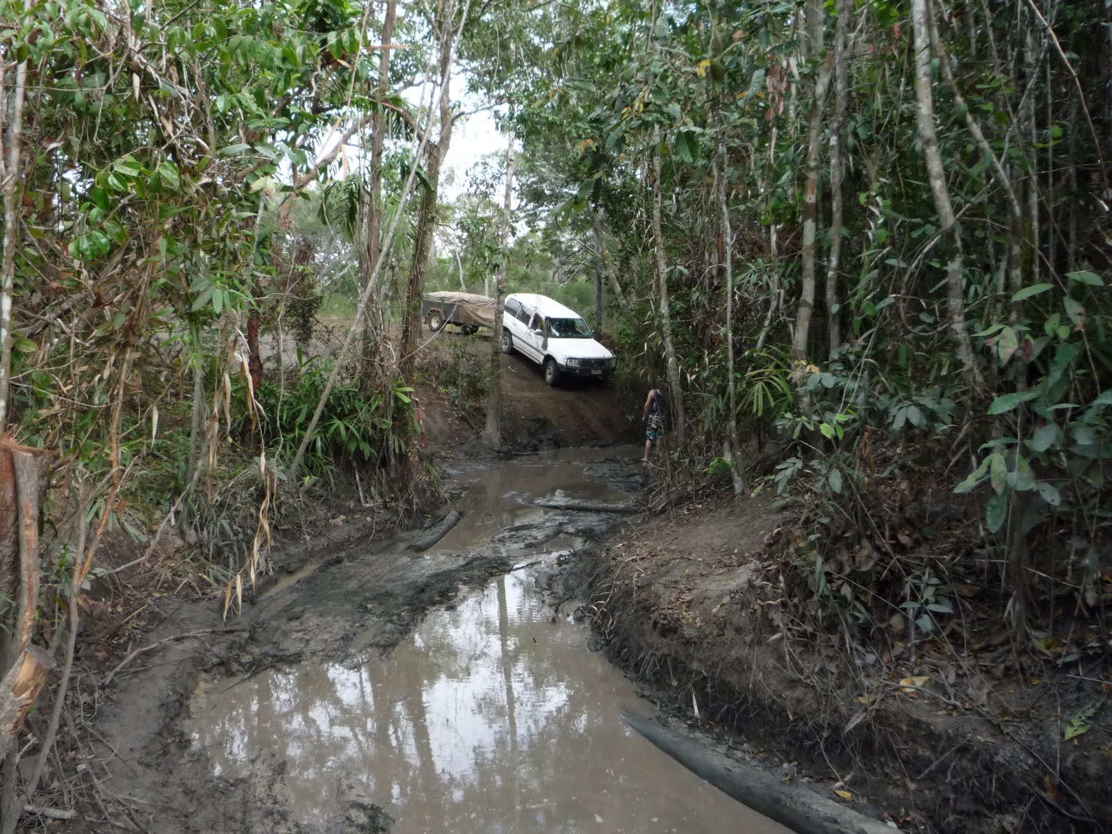
On the road again and it was only 50 odd km to the Weipa turnoff where we thought the road would get worse, but though it narrowed slightly we were pleasantly surprised how good it was right through to Bramwell Junction Roadhouse, passing another old telegraph station (Moreton) along the way. Bramwell is where the Old Telegraph Track branches off. We grabbed some drinks and topped up with fuel, with the girl there telling me that at the first creek crossing (4km away) they’d been winching vehicles up there during the last week. I thought since we’d come all this way we’d at least head down and see what condition it was in. When we got there (Palm Ck) I first thought there must be another option as there were tracks heading right along the bank – soon realised though there was only one option, straight ahead and down a 3ft drop into mud and logs! A Troopie pulled up and said he’d hang around and pull us out if we wanted to give it a go – what the heck, we aired down and got the recovery gear ready. My passengers abandoned ship and left me to it, as well as making sure the moment was captured on camera, no matter how it turned out! In the end it was pretty straight forward, after slipping down the bank and coming to a crunch at the bottom it was a slow cruise across the creek and a bit of wheel slipping to get up the steep wet muddy bank on the other side. Only damage was one of the trailer stays being bent up – one major water crossing down, only 13 to go! Ducie Creek was the next one, and are new mate in the Troopie (as different to our old mate Mr Truckin) hung around to help out again if needed – apart from some more crunching no issues at all. We had one more crossing at North Alice Ck before setting up camp on the south bank of the Dulhunty River. This southern bit of the track gets a lot less traffic then the northern section and is some of the best 4wding you can do. It’s basically just two wheel tracks heading along the old telegraph line, with numerous diversions wherever the old track had been washed out or a tree had fallen across the track. Many of the original telegraph poles are still standing, though all the isolators have been souvenired. Apart from our Troopie mate we didn’t see anyone else at all along the track except at the camping spot – thankfully most people do it from south to north, reducing the real chance of a head-on.
Up early the next day as we wanted to make sure we got to the popular Eliot/Twin Falls campsite early enough to get a spot. After Dulhunty Rv, the next crossing of the day was Bertie Ck which was a great rocky crossing where we had to head upstream 50m or so before exiting. It was another 4km before we had to make the decision whether to take the bypass around the famous Gunshot Creek crossing or not. I thought what the heck let’s head the 12km up the OT track to see what condition the crossing was in and whether there was a “chicken” track. We got there to see a guy in a 80 series Landcruiser trying to get up the “chicken” track, all he proceeded to do was chew the hell out of the track and didn’t get anywhere. He finally decided to do what he should have done first up and that was winch himself up! He actually broke the casing on his winch – karma. I didn’t fancy driving the 12km back at 20kmh so thought we’d give the crossing a go as he was heaps of people around to help out, or more to the truth waiting for people to come a croppa! So out the shovel came and I did a bit of work repairing some of the damage the d-head in the 80 series had done. Then once again all passengers abandoned ship – it was a very slow entry and then a slip into the mud and crap at the bottom of the creek. Once in the creek bed itself we were virtually home and hosed – it was nice to have one of the guys originally spectating guiding me through. (Pete – reckon the Falcon might have struggled to get through this one, even with the bench seat!) Stopped for photos under the “trophy” tree and then cruised up the opposite bank. No damage at all this time! (If interested google “Gunshot Creek” or do a search on YouTube and see some silly things boys have done in their toys up and down the harder chutes at Gunshot). After that we had two more crossings at Cockatoo and Sailor Creeks before getting to the Eliot Falls Campground around lunch. Once camp was setup we bolted down to the Saucepan Falls to cool off. It was bloody good feeling having a beer later knowing we’d had such a great day 4wding.
Sleep in the next day and lazing around camp, I even managed a shave which Louise was pretty happy about. We swum at all of the great swimming spots here – Eliot and Twin Falls and The Saucepan Falls, all of which are within 500m of each other. The water is so clear and a great temp. In the arvo we got out the snorkel gear and snorkelled up and under Eliot Falls, seeing some Catfish and other larger fish. There are some deep pools here, filled with logs and rocks and I couldn’t help but think how a freshie could easily sit on a ledge down there and we’d hardly notice! The wildlife of note here is fruit bats (or flying foxes) and there’s thousands upon thousands of the upside down critters. They stink a lot and you’ve got to be careful (or lucky) when walking down for swim that you don’t get shat on. Late arvo and they take to the sky, a pretty amazing site. We’re running out of fresh food, in fact food in general so Louise has been very creative in the culinary stakes – hanging out for some fresh fruit.
What a day! We left the trailer at Eliot Falls Campground and headed north to do the final section of the OT track to the Jardine River, which is the biggest river on the Cape. Things got interesting early, at Canal Ck, the first water crossing only a km down the track I got the rear diff caught up on a rock ledge heading into the creek, in the end the solution was a little more right foot and we were on our way. This part of the track is amazing with probably the most challenging water crossings, most having steep entry and exits with eroded banks. We got through Sam, Mistake and Cannibal Creek crossing without any problems. Next was Cypress Ck which was a bridge of sorts – a number of poles or logs just laid down over a small gully - Louise’s precise directions got us over that safely. After this we came to a serious crossing which was only marked on the map as a ford – it was quite long and reasonably deep in the middle. It was at this point two 80 series Cruisers caught up to us as we were working out which was the best option across. I followed the first one over (in case we needed a snatch) with no problems. We left the other one (which was petrol) to fit his water blind and headed on. We got to Nolan’s Brook (also known as Bridge Creek) to find the log bridge that used to be there is no more. As this was the deepest crossing on the track we decided to wait for our new friends, who were from Seville – it is a small world. Once they arrived we walked the crossing and decided one entry was better than the other. Not sure why but we were the first vehicle to give it a go – 2nd Low range and with the front locker engaged I headed through (crew again decided watching was better!). The bottom dropped off in the middle with really loose coarse sand and for a moment as I lost traction climbing out of the deep water I thought I was in trouble, but the trusty Toyota pulled itself out. Next was the guy with the diesel, and as he was climbing out he lost traction and was stuck – we chucked a snatch strap on and I pulled him out. Only problem was he’d already been in the water for a few minutes and when he opened the doors on firm ground, water came pouring out from everywhere – sadly one of the casualties was their laptop. He was a bit unlucky as I’d probably chewed up the bottom a bit, though he was running higher tyre pressures and didn’t have any lockers. We found out later that three other vehicles had got across after us but they all had lockers front and rear). Mr Diesel then pulled Mr Petrol though after we joined two snatch straps. Once we were all across we had a swim and somehow a fruit cake appeared (and a thankyou beer) from one of the 80 series which tasted great. Off again and it was a cruisy trip up to the Jardine River, and it wasn’t what I’d expected - rather than being deep, muddy and dark (and teeming with crocs) as I had envisaged, at this point it was quite shallow, wide and with white sand beaches similar to the Murray River near Yarrawonga and Cobram. We checked out the old vehicle crossing (they now have a ferry downstream) and it’s over 140m across, and probably averages 2 to 3 feet deep. People still do it and even walk it first to check for holes, soft sand etc keeping a watchful eye out for crocs. On the way back to camp we took the main road and stopped off at Fruit Bat Falls for a swim, another great set of falls on the upper bit of Eliot Creek with pristine clear waters. Back at camp we enjoyed a nice cold beer.
We left Cairns quite eager to get on the road again, and not at all disappointed about leaving the hussle & bussle of Cairns behind, including traffic lights, the first we’d encountered since Mildura! We took our time cruising along the Capt Cook Hwy which hugs the coast similar to the Great Ocean Road. Our first real stop was Mossman Gorge which is an amazing spot where we did a great walk, taking in the main gorge as well as a side stream and the surrounding rainforest. Popular spot, and we were lucky to get a spot with the trailer, not sure how the coach we saw there made it up the narrow road with cars parked every which way – not sure how some people get their license, though to be fair when most of those oldies got their license tight parking wouldn’t have been an issue.
From there we had a late lunch in Mossman. The cane harvesting season is in full swing and the mill there was working overtime, as well as the many cane trains heading there to offload their cargo. We didn’t get much further up the coast before setting up camp at Wonga Beach, at a nice little c-park right on the beach. Also had heaps of wildlife, with orange-footed scrub fowls (these guys build a huge mound to incubate their eggs), brush turkeys and the most amazing was bandicoots everywhere – something sadly we don’t see in Vic anymore. The kids loved this place as it had two big pools, one of which had a water slide. We decided to base ourselves here another day and spent the next day checking out the coast north, starting with Daintree. It’s a nice little village but we were surprised how settled or cleared the valley was. To get further up the coast we had to cross the Daintree Rv by ferry, and did a number of the great walks in the parks along the coast before getting to Cape Tribulation. Amazing how many little B&Bs, crafty type places and tour companies that now operate along this strip, well at least for 6 months of the year.
Next day we packed up and headed up the same way and on the ferry again, but this time with the trailer in tow. The highlight was the Bloomfield track which basically starts at Cape Trib and heads north to Bloomfield where it joins the road to Cooktown. Apart from some steep sections it was quite easy and in good nick. We ambled along as it made its way through virgin rainforest basically following the coast quite closely, though it was a shame there was no place to stop and check out any views, we had to make do with glimpses through the vegetation. The water crossings weren’t high with no rain recently and we stopped for lunch at one and the kids spotted heaps of fish, yabbies/crayfish and a couple of eels. That night we stopped at a little joint called Ayton, just north of Bloomfield. The trip next day into Cooktown was very short and cruisy.
Cooktown is a great little place, not too big or touristy, but still large enough to have the nice to haves like a bakery, IGA and of course a pub or four. Today was spent checking out a couple of the great museums here – after all this was the joint one James Cook spent over a month repairing some old rotting boat called the Endeavour or something! We also found out we’ll have to vote at either Weipa or Thursday Island, most likely we’ll be closer to TI so we’ll need to make sure we’re close on election day! Lunch was spent down the beach, no swimming again – damn those pesky crocs. Late arvo Lachlan tried his hand at fishing off the wharf with a hand line – one undersized something or other was his reward, but it was a nice way to spend a lazy afternoon. The girls did a big shop in readiness for us heading north tomorrow to Lakefield NP and beyond. The next blog might be a way off as I’m sure the NextG options from here north are either minimal or non-existent.